Online Maps — Image Web Tilesets

TNTmips can convert your custom imagery, scanned maps, and displays of thematic map data into standard web tilesets, which store the data in an image format (JPEG, PNG, and TIFF) for presentation in a geomashup. Standard web tilesets are great for providing a visual representation of your map or imagery. You can create image tilesets that conform to the Google Maps tileset specification, which can be viewed in Google Maps, Open Layers, and Bing Maps, or tilesets that conform to the KML Super-Overlay structure, which can be viewed on the web in the Google Earth browser plugin or locally using the desktop Google Earth application.
Unlike geometric web tilesets, image tilesets do not incorporate any attribute information that could be used to automatically create a legend or provide mouse-click attribute information. But if you are comfortable with HTML, you can provide links in the geomashup sidebar to images or PDF files containing legends, cross-sections, and other information, as in the Skykomish River Geologic Map example below.
Click icons below map to open geomashups with:
Nebraska OrthoImagery for Multiple Years
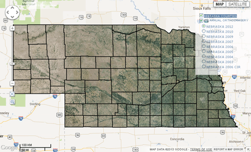
Orthoimagery of the state of Nebraska for the years 2003 to 2012 is shown in this geomashup. The imagery for each year is a separate web tileset, and the geomashup presents these layers in a group that allows only the currently selected layer to be visible. Using this geomashup it is easy to identify changes in land use, cropping patterns, and urban development through time. An additional overlay shows county and township-range boundaries and labels that have been rendered to an image tileset. The orthoimagery was collected by the USDA National Agricultural Imagery Program and converted to web tilesets in TNTmips.
Pennsylvania Stream Network
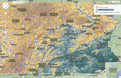
Stream courses and elevation data for the entire state of Pennsylvania are depicted in this geomashup of tilesets created in TNTmips. The Color Shaded Relief layer was created from an NED30 elevation raster and a shading raster derived from this elevation raster. These layers were overlaid with partial transparency and converted to a standard web tileset using the Render to Tileset procedure in the Display process.
The stream tileset was produced from networked stream center lines with added stream order attributes computed in TNTmips from the NED30 elevation raster. A simplified version of the stream network was developed for each reduced-resolution zoom level in the output tileset. To do so, the stream network was pruned by stream order and by length of dangling lines, and line complexity was progressively reduced using the Vector Filters process. Each zoom level in the Streams tileset was created separately using the Render to Tileset procedure. These zoom level tilesets were then assembled into a complete Streams tileset using the interleaving capabilities in the Merge Tileset process. The Assemble Geomashup process was then used to assemble these components and produce the auxiliary HTML files used to publish this demonstration.
Skykomish River Quad Geologic Map
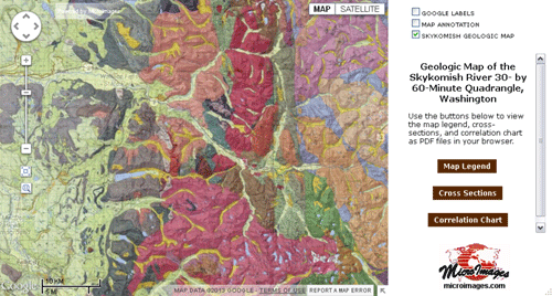
These image tilesets for the Geologic Map of the Skykomish River 30 x 60 Minute Quadrangle, Washington (USA) were created in TNTmips from images derived from a PDF file published by the United States Geological Survey (Geologic Investigations Series I-1963). Adobe Photoshop was used to extract portions of the map sheet PDF as images, which were then converted to image tilesets. The map tileset is shown partially transparent to allow topographic and other features from the base map to partially show through. The geomashups displaying these tilesets (created in the Assemble Geomashup process in TNTmips) include a sidebar which includes a separate manually-created HTML file with buttons that link to PDF files showing the Map Legend, Cross Sections, and a Correlation Chart.
- More Tilesets:
- from imagery ...
- from maps ...
- for plan reviews ...