Online Maps — Image Web Tilesets from Maps
You can convert raster versions of thematic maps (such as scans from paper maps) to image tilesets in TNTmips using the Export Raster Tilesets process. You can also convert displays of styled map layers (including map layouts consisting of many map layers) to a single image tileset in the Display process using the Render to Tileset operation. If you are comfortable with HTML, you can provide links in the geomashup sidebar to images or PDF files containing legends, cross-sections, and other information.
Genesee County, Michigan Topographic Map
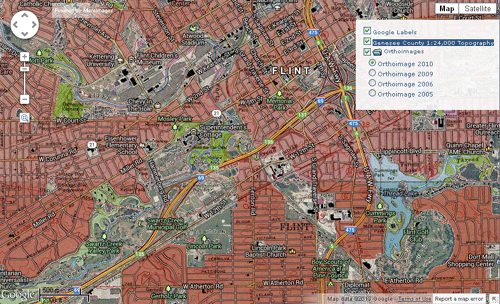
This geomashup overlays an enhanced 1:24,000-scale USGS topographic map of Genesee County, Michigan on the corresponding annual USDA 1-meter orthoimage coverage of the county. Orthoimagery from multiple years is provided in a separate group with radiobutton controls that allow you to select one year at a time; the entire orthoimagery group can be toggled off or on as desired.
The map layer is a tileset with transparent background prepared from the Super-DRG digital versions of these maps covering the United States in county units. Super-DRGs are a product of advancements in scanning technology since the creation of the original DRGs by the USGS. As a leader in the field of digitization, the W.E. Upjohn Center for the Study of Geographical Change at Western Michigan University specializes in large-format, flat-bed scanning that eliminates the possibility of damage to any map or document. Using GIS Scanners developed exclusively for the Center by Lumiere Technology, Paris, these Super-DRGs are of the highest quality and geometric accuracy. The result is an extremely high-definition map product of the same resolution as the original DRG, such that the 1:24,000 and 1:25,000-scale maps can be effectively used with 1:12,000-scale imagery (digital orthophotos). This Super-DRG product provides nationwide coverage of the 7.5-minute 1:24,000 and 1:25,000-scale USGS topographic quadrangles in a GIS-ready format (mosaic constructed by county). The dataset is georeferenced and color-enhanced to provide for overlay with imagery and other forms of GIS data. This product is ideal for change detection analyses and for adding depth to an existing dataset's temporal dimension. TNTmips was one of a suite of software products used in the preparation of the Super-DRGs.
The current Super-DRG coverage of the United States is the first component in a larger series now being developed by The Center and called the Authoritative U.S. Topographic Maps Initiative. This augmentation will provide high-accuracy, multiscale, high-definition historical map sets.
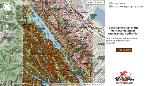
Montara Mountain, California Topographic Map
Stream courses and elevation data for the entire state of Pennsylvania are depicted in this geomashup of tilesets created in TNTmips. The Color Shaded Relief layer was created from an NED30 elevation raster and a shading raster derived from this elevation raster. These layers were overlaid with partial transparency and converted to a standard web tileset using the Render to Tileset procedure in the Display process.
The stream tileset was produced from networked stream center lines with added stream order attributes computed in TNTmips from the NED30 elevation raster. A simplified version of the stream network was developed for each reduced-resolution zoom level in the output tileset. To do so, the stream network was pruned by stream order and by length of dangling lines, and line complexity was progressively reduced using the Vector Filters process. Each zoom level in the Streams tileset was created separately using the Render to Tileset procedure. These zoom level tilesets were then assembled into a complete Streams tileset using the interleaving capabilities in the Merge Tileset process. The Assemble Geomashup process was then used to assemble these components and produce the auxiliary HTML files used to publish this demonstration.
Otoe County Common Land Units
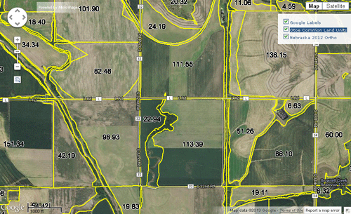
This geomashup displays a tileset showing agricultural field boundaries for a Nebraska county. Labels showing the number of acres in each field polygon are shown at the higher zoom levels. The transparent background allows an orthoimagery tileset to be visible as a reference.
The source of the field boundaries is the 2007 edition of the U.S. Department of Agriculture Common Land Units (CLU) dataset for the county, which was imported to a TNTgis vector object. Each zoom level in the CLU tileset was rendered to a separate tileset in the Display process in TNTmips. These tilesets consist of PNG tiles to provide a transparent background for the boundaries and labels. For each Google Maps zoom level, styles for the CLU vector were adjusted to provide polygon boundary widths and label sizes appropriate for that map scale. The acreage labels were dynamically generated in the vector display using acreage values in the polygon database. These individual CLU zoom-level tilesets were then merged to a single tileset using the Merge Tilesets process in TNTmips. The Assemble Geomashups process was used to combine the CLU tileset with the Nebraska orthoimage tileset.
10-Meter Elevation Contours of Japan
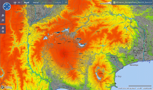
OpenGIS, the authorized MicroImages reseller in Japan, has used TNTmips to create a tileset of the 10-meter contours and other topographic map features for all of Japan. This tileset uses only PNG tiles to publish these map features to provide a transparent overlay for use in popular geoviewers. This tileset can be viewed as a transparent overlay in Google Maps and Bing Maps from the OpenGIS web site using the links at the left.
The map tileset depicts topographic contours color-coded by elevation. A number of other reference layers are also shown in various colors, including coastline, water boundaries, road edges, railway centerlines, building footprints, and administrative boundaries.
This country-wide topographic tileset was created from individual tilesets for each of Japan's 47 prefectures. For each prefecture tileset, all map layers were displayed together in TNTmips with appropriate styling and converted to a Google Maps tileset using the Render to Tileset procedure. The maximum Google Maps zoom level for each prefecture tileset is 16. At this zoom level each screen pixel depicts a ground area about 2 meters across at these latitudes. The complete set of tilesets for all 47 prefectures includes about 2.3 million tile files and requires 23.3 GB of hard drive space. The Merge Tilesets process in TNTmips was then used to merge the prefecture tilesets into the single country-wide topographic tileset you are viewing here.
The source data for all map layers is the Kiban Chizu Joho (Fundamental Infrastructural Digital Map Information) published by the Geospatial Information Authority of Japan (GSI) at a native scale of 1:25,000. There are approximately 4600 paper maps in this series. The digital version of these maps for each prefecture is available for free download from GSI, in Japanese or can be ordered on CD. OpenGIS converted each map layer from its native XML format to a shapefile using a GSI utility program. All map feature shapefiles were imported to TNTgis vector objects for added flexibility in styling, with the exception of building footprint shapefiles, which were used directly. The approximate total size of all input files is 10.9 GB.
Base of the Principal Aquifer for the Elkhorn-Loup River Basins, North-Central Nebraska
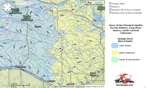
This geomashup of three tilesets depicts the elevation and geology of the base of the principal groundwater aquifer underlying much of the Sand Hills region of north-central Nebraska. The geomashup includes a generalized geologic map of the base of the aquifer, contours of the elevation (in feet above sea level) of the aquifer base, and surface streams. The geologic map layer has been set to be partially transparent to allow features in the base maps and imagery to show through the map. The geomashup sidebar includes a simple legend graphic for the geologic map.
The source maps are distributed as shape files accompanying United State Geological Survey (USGS) Scientific Investigations Map 3042. The shape files were imported to vector objects in TNTmips and edited and filtered to create appropriate map detail and styling for each tileset zoom level. Each zoom level was then created separately from its source vector object using the Render to Tileset procedure in the Display process in TNTmips. These zoom level tilesets were then merged into a complete tileset for each of the map overlays.
The Assemble Geomashup process in TNTmips was used to create the mashup of the three overlays and include a sidebar with the legend graphic provided by a secondary custom HTML file.
Afghanistan Geologic and Mineral Resource Map
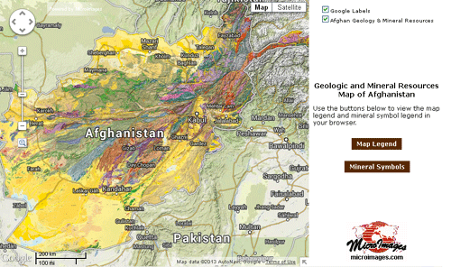
The tileset in these geomashups was created in TNTmips from a map published as a PDF file by the United States Geological Survey (USGS) as Open-File Report 2006-1038. The map by Jeff L. Doebrich and Ronald R. Wahl includes geologic map unit boundaries and locations of mineral resource occurrences compiled from various. TNTmips was used to compile the source data and prepare the cartographic rendering.
This geomashup has been provided with a sidebar containing the layer controls, logo graphic, and custom content derived from a secondary HTML file. The custom content includes buttons linking to PDF files containing a map legend and a key to mineral symbols.
Afghanistan Topographic Map
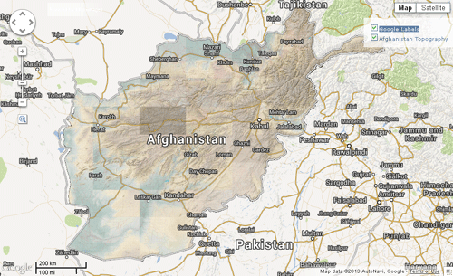
These geomashups display a tileset created in TNTmips from a mosaic of 32 individual topographic maps prepared at a scale of 1:250,000 and published as PDF files by the United States Geological Survey (USGS). Contours and stream paths used in the source maps were generated in TNTmips terrain modeling processes. TNTmips and other products were also used to prepare the cartographic rendering and PDF files. MicroImages extracted the map images from the PDF files, georeferenced them, and then mosaicked them to an image web tileset.
Additional information with regard to using these "reconnaissance maps" can be found in the USGS Open File Report associated with each map.
Afghanistan Geologic Map
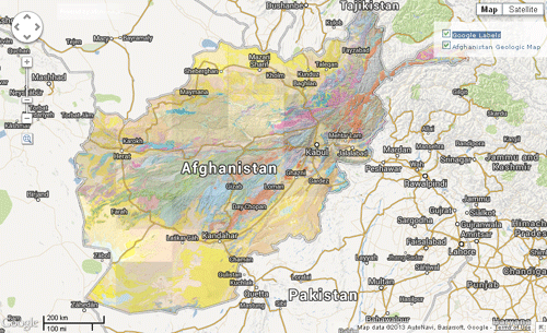
These geomashups display a tileset created in TNTmips from a mosaic of 32 individual geologic maps prepared at a scale of 1:250,000 and published as PDF files by the United States Geological Survey (USGS). The shaded-relief background and topographic contours in the source maps were generated in TNTmips from SRTM digital elevation data. TNTmips and other products were also used to prepare the cartographic rendering and PDF files. MicroImages extracted the map images from the PDF files, georeferenced them, and then mosaicked them to an image web tileset.
Additional information with regard to using these "reconnaissance maps" can be found in the USGS Open File Report associated with each map.