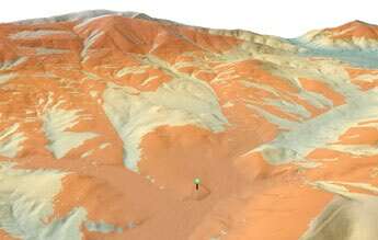
Viewshed (orange) computed for a 50-meter tower (stalked green point) for a LIDAR DEM with 2.5-meter resolution
TNTmips provides a number of tools for analyzing and processing terrain data. You can view, process, and classify large LIDAR point clouds. The
Topographic Properties process computes general terrain characteristics such as slope, aspect, shading, and curvature for digital elevation model (DEM) raster objects. The Viewshed process identifies terrain areas that are visible from input points on or above the surface. The Cut and Fill Analysis process compares two DEMs of the same area and identifies locations where their elevation values differ. The Watershed Process models the movement of water over the land surface. The Surface Modeling process provides transformations between different elevation representations: DEMs, contours, and triangulated irregular networks (TINs).
See also:
Tech Guides on Terrain Operations and
Analyzing Terrain and Surfaces tutorial.
relief shading from DEM
slope magnitude from DEM
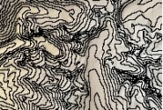
contour lines from DEM
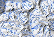
watershed flowpaths
Terrain Operations Highlights
- Display, classify, and analyze LIDAR point clouds with tens of millions of points in efficient LAS file format
- Work with large-size DEMs at any resolution (detailed local LIDAR DEMs to continent-sized 90-meter SRTM data)
- Compute slope magnitude, aspect (slope direction), and profile (vertical) and plan (horizontal) curvature
- Compute relief shading with with virtual illumination from any direction to aid terrain visualization
- Automatically determine illumination parameters for relief shading to match a particular location, date, and time of day
- Choice of several methods for determining the local surface shape when computing slope, aspect, shading, and curvature
- Determine viewshed from points placed manually or loaded from any geometric object (vector, CAD, or shape)
- Adjust height above surface indepently for each viewpoint
- Adjust field of view independently for each viewpoint by entering values or using on-screen graphics
- Determine changes in elevation through time due to erosion, landsliding, or human activities
- Derive stream networks, watersheds, and subwatersheds along with many geomorphic and hydrographic attributes
- Compute upstream catchment area and downstream flowpath for specific locations by manually placing seed points in a view of the DEM or by loading them from a vector geodata layer
- Compute hydrologic/geomorphic characteristics of the DEM cells: specific catchment area, compound topographic index (CTI), maximum upstream flow distance, and downstream flow distance
- Perform contouring, surface fitting, and triangulation operations