Nebraska Land Viewer
Statewide Orthophoto Atlas on DVD

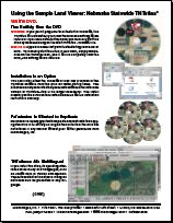
The Nebraska Statewide Land Viewer TNTatlas DVD was distributed with the hardcopy release of the TNT products 2005:71. It uses a single natural color image of all of Nebraska.
The base image was mosaicked into a single uncompressed raster object of 1 terabyte from approximately 6000 orthophoto JPEG images of 1-meter resolution. It was then compressed 200:1 using JPEG2000 for use in this atlas. This huge compression retains the 1-meter resolution by blurring the highest frequency variability within cultivated fields and natural areas (i.e., primarily loses crop row structure and small shrubs).
Documentation and Descriptions:
Note: This is a sample atlas only. MicroImages is a software developer and is not in the business of publishing atlases. This sample is provided in order to demonstrate the features and use of the TNTatlas product, which our clients use to prepare and distribute a wide variety of geospatial products that can be used on any Windows, Mac, LINUX or UNIX computer. The FREE TNTatlas software can be distributed on CD, DVD, or other media along with digital map, image, and database materials in a geographically interrelated atlas structure.
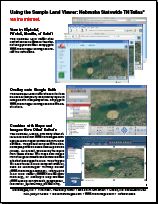
This atlas demonstrates some of the newest interactive features that can be designed and used in the TNT products and incorporated into a TNTatlas. It is distributed freely so you can experiment with its features and capabilities.