Online Maps — More Geometric Web Tilesets
Lancaster County Floodplains
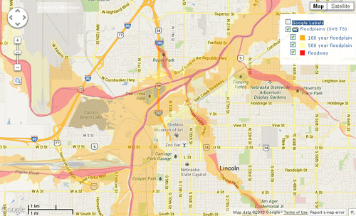
These geomashups show a geometric tileset depicting the floodway and 100- and 500-year floodplain areas in Lancaster County, Nebraska. A legend created dynamically from the tileset is shown in the layer controls, and left-clicking on a flood area pops in an information balloon identifying the type. The flood areas are shown with partial transparency to let base map/image features show through.
The styled floodplain polygons were rendered to the tileset from a vector object using the Export Geometric Tileset process in TNTmips. Examples of both SVG and KML geometric tilesets are shown. The polygon attribute information was transferred to the tilesets automatically using the contents of a database field specified in the process.
Lancaster County Urban-Rural Land Ownership
Using KML geometric tilesets for parcel polygons
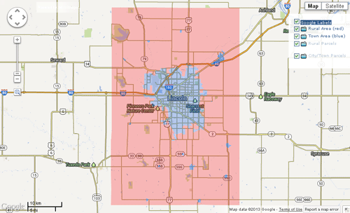
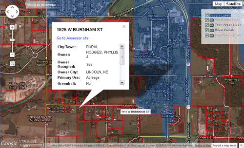
These geomashups depict the 108,000 property parcel polygons for Lancaster County, Nebraska, with attached database information released by the County Assessor's Office in December 2011. Because most rural parcels are much larger than urban parcels, the rural and urban parts of the county have been segregated into different layers for presentation over different zoom level ranges. At startup the entire county area is shown with rural (red) and urban (blue) areas indicated by partially-transparent overlays provided by simple KML files (rendered from vector objects using the Display process in TNTmips). Clicking on an area pops in an information balloon directing you to zoom in to that area to see the parcel information. As you zoom in, parcel polygons contained in KML geometric tilesets are shown beginning with Google Maps zoom level 14 for the rural areas and zoom level 17 for Lincoln and the other municipalities in the county. Each parcel polygon is shown as a red outline with a mostly transparent red fill. Hovering the mouse cursor over a parcel polygon shows the property address (if available). Clicking within a polygon pops in an information balloon with additional information such as owner's name, assessed value, primary use, and acreage, along with a link to the County Assessor's web site for even more information.
The Export Geometric Tileset process in TNTmips was used to convert vector objects containing the original parcel polygons into the KML vector tilesets showing the parcels at zoom levels 17, 18, and 19 for the urban areas and zoom levels 14 through 19 for the rural areas. The source vector objects included a virtual attribute field constructed from a number of parcel database fields to provide a multiline DataTip. During the tileset conversion this DataTip information was automatically transferred to the KML structure for each parcel to provide the data source for the information balloons.
Lancaster County Urban-Rural Land Ownership
Using image tilesets for parcel boundaries and KML geometric tilesets with points for parcel attributes
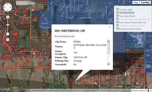
In these property parcel examples, all of the polygons have identical styling; only the parcel data differs between polygons. A geometric tileset is therefore not required to represent the parcel boundaries, but only to provide a link to the parcel attributes. The parcel geomashups opened from the links to the left take this approach, using image tilesets (with transparent-background PNG tiles) to map the rural and urban parcel boundaries. Access to the parcel data is provided by KML geometric tilesets that have a point in the center of each parcel polygon. Hovering the mouse over a parcel point shows the property address (if available); clicking on a parcel point opens the information balloon with full parcel information.
To prepare these geomashups, TNTmips was used to create vector objects with a point for each polygon and the polygon attribute tables were transferred to the points. The Export Raster Tilesets process was used to convert the polygon boundary objects into image tilesets, and the Export Geometric Tileset process was used to convert the vector point objects to KML geometric tilesets. For KML point data it is not necessary to create point files over multiple zoom levels; a single-level tileset can be created at the minimum zoom level at which the points should be displayed (with appropriate spatial density of points). In the Assemble Geomashup process, a single-level KML point tileset can be set to display at its native zoom level and any higher-numbered zoom level. In these examples the rural parcel points were created for zoom level 14 and the city parcel points for zoom level 17, but both are visible through zoom level 19. Single-level KML point tilesets save on preparation time and file storage requirements.
Geologic Map of the Amboy and Ariel Quadrangles, Washington
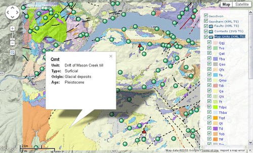
This geologic map of the Amboy and Ariel quadrangles, Washington, is a geomashup of three KML geometric tilesets, an SVG geometric tileset, and a KML file. Legends are set to be dynamically created for the Map Units layer (polygons) and Faults layer (lines). The TNTmips interactive Geomashup process, which was used to assemble these layers, allows you to specify the creation of a legend for individual geometric layers (single KML files or KML or SVG geometric tilesets) in the mashup. A legend entry is created for each unique style and corresponding attribute value in the source geometric object. The folder icon for a legend in the geomashup layer controls serves as a hide/show control. In this example the Map Units legend is set to be initially expanded and visible, while the Faults legend is set to be initially closed.
In order to create this geologic map, corresponding vector map layers from two adjacent map quadrangles were merged in TNTmips using the Vector Merge process. The database tables attached to these vector objects were edited to have identical field names and types so that the tables could be seamlessly merged along with the map data. The styled vector map layers were converted to KML and SVG geometric tilesets in the Export Geometric Tileset process in TNTmips. The Geochron layer, which contains only a few point elements, was rendered to a single KML file using the Render to KML operation in the Display process.