Comparing SVG & KML Geometric Tilesets
SVG(Z) and KML Geometric Tilesets contain map data in tiled vector graphic form with included attributes, but have somewhat different characteristics and capabilities. For the widest support of TNTgis vector styles and fast efficient display in 2D geoviewers (Google Maps and Open Layers), choose SVG or SVGZ geometric tilesets. For 3D display in Google Earth (desktop or browser) choose KML geometric tilesets. A more detailed comparison is presented below.
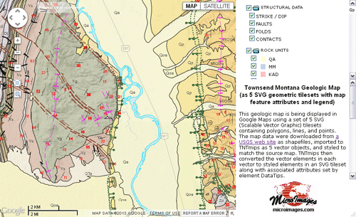
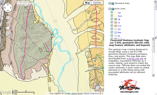
Townsend Montana Geologic Map
| SVG / SVGZ Geometric Tilesets | KML Geometric Tilesets | |
| Element Styles | Extensive support for element styles. | Limited element style support. |
| Points | Vector graphic symbols rendered from standard point symbols and custom CartoScript symbols. | Linked PNG images rendered from standard point symbols; no support for CartoScript symbols. |
| Lines | Support for solid colors, line patterns, and custom CartoScript styles. | Solid color lines of varied widths; dashed lines; no support for custom CartoScript styles. |
| Polygons | Filled polygons with transparency; support for line patterns for polygon borders. | Filled polygons with transparency; solid and dashed polygon borders. |
| Labels | Converted to vector graphics. | Converted to point elements with text label. |
| Dynamic labels | Converted to vector graphics. | Not supported. |
| Tile stored size | Small tiles with efficient storage. | Larger tile files, especially for lower zoom levels. |
| Line Detail | Can maintain higher line feature complexity at acceptable tile sizes (can use lower line thinning factor when creating tileset). | Lower line complexity required to maintain acceptable tile sizes (requires higher line thinning factor when creating tileset). |
| Display Speed | Fast at all zoom levels. Browsers have native support for SVG rendering. | May be slow due to larger tile sizes, especially at lower zoom levels. Browsers must convert tiles before rendering. |
| Use In | Google Maps, Open Layers. | Google Maps, Open Layers; view in 3D in Google Earth. |
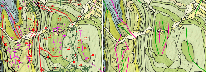
SVG and SVGZ geometric tilesets (left) can display complex line and point styles, including TNTgis vector styles created by custom CartoScripts. KML geometric tilesets (right) are limited to much simpler line styles and point symbols.