Lincoln Property Viewer TNTatlas
Lincoln, Nebraska
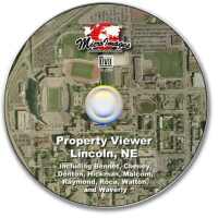
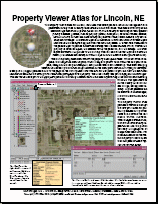
The Property Viewer atlas for Lincoln, Nebraska was developed as a model for management and presentation of city-wide or county-wide data in the form of an atlas. This atlas shows how you can assemble high resolution airphotos (30 cm or 1 ft) with a variety of vector layers that represent publicly available geodata, such as property parcels, floodplains, street centerlines, schools, historic districts, onstreet and offstreet bicycle/pedestrian trails, school districts, city boundaries, and townships. An elevation layer is also included. Information from all of these layers is shown in the DataTip that appears when the mouse is paused. A virtual field was added to the parcels layer to provide a multiline DataTip that includes address, owner, whether the property is owner occupied, the assessed value, the parcel ID, and the acreage. All other layers contribute a single line to the DataTip when an element in that layer is beneath the cursor (area features and rasters) or within 16 pixels of the cursor location (points and lines). The DataTip background color reflects the property�s floodplain status. When out of the floodplain, the background color is green, which changes to yellow when within the 500 year floodplain, orange for the 100 year floodplain, and pale red when over a floodway.
Documentation:
- TNT products V7.0 Release Notes, p. 51 (November 2004): Lincoln Sample Atlas