Georeference Auto-Register
The Auto-Register operation in the Georeference process can automatically generate hundreds of control points for an image using a local reference image or an online web tileset. Control points can be colored by residual value to easily identify poorly-fitting points. See the Auto-Register to Reference Image Technical Guide for more information.
Auto-Register
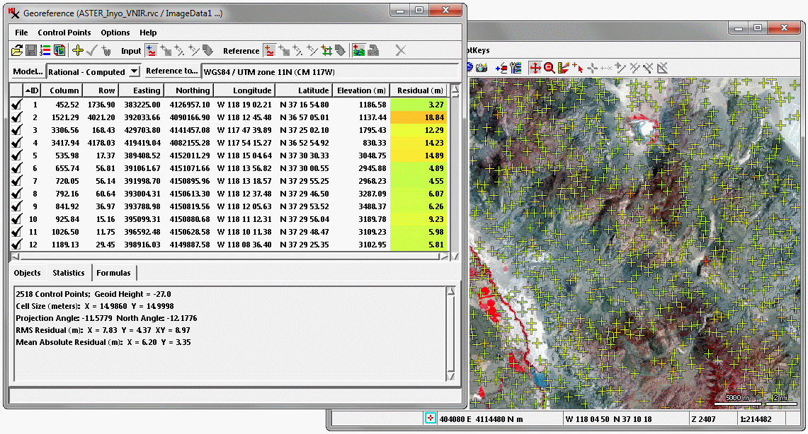
In this georeference example, over 2500 control points were generated by the Auto-Register operation for an ASTER scene of a mountainous area in eastern California, USA, using a reference 1-meter orthoimage tileset. Elevation values were also automatically assigned to the control points from a reference 10-meter National Elevation Dataset elevation raster. These dense 3D control points were used to derive a set of Rational Polynomial Coefficients for use in orthorectifying the image in the Automatic Resampling process.
Auto-Register Landsat to a Global Web Tileset
The online web tilesets hosted at microimages.com can be used as reference images in the Auto-Register operation. In this example a Landsat image was regeoreferenced using the global Landsat 742 web tileset.
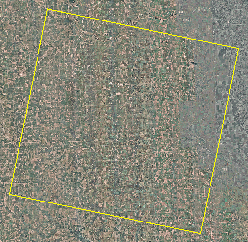
Input Image
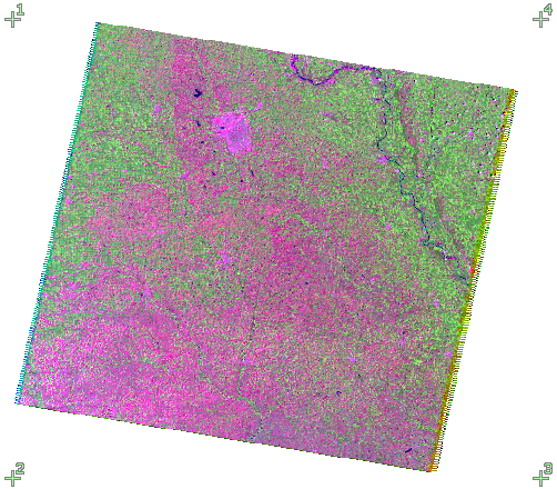
Landsat 5 image acquired during the 2009 growing season over an area in southeast Nebraska, displayed in false color with Band 7 = Red, Band 4 = Green, and Band 2 = Blue to produce an "infragreen" image. The image is 8,201 columns by 7101 lines with a cell size of 30 meters. The four corner control points produced from the georeference supplied with the image are also shown.
Reference Image
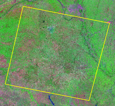
Global Landsat 742 Google/Bing Maps tileset accessed in the Georeference process via the web from microimages.com. The yellow box shows the approximate area covered by the Landsat 5 scene. This reference tileset of global land areas was constructed from false color pan-sharpened Landsat imagery with a cell size of 14.25 meters provided by NASA. All TNTmips users can access this tileset on-line from microimages.com to use as a reference layer for displaying, georeferencing, or editing their local geodata.
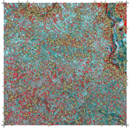
Auto–Register Result
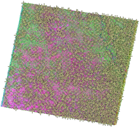
Auto-Register produced 1740 control points. Using smaller Generated Point Spacing and/or larger Maximum Point Residual values would produce more control points.
Auto-Register Settings:
Match green spectral component in each RGB image:
Input Display Green --> Reference Display Green
Initial Accuracy Estimate: 5 cells
Generated Point Spacing: 100 cells
Maximum Point Residual: 2.0 cell
Correlation Patch Size: 128
Maximum Adaptive Model: As Specified (Affine)
RMS Residuals:
X = 0.27 cells, Y = 0.31 cells,
XY = 0.41 cells, (Model = Affine)
Mean Absolute Residuals:
X = 0.20 cells, Y = 0.24 cells
Auto-Register to Local SPOT 5 Image
Input Image

SPOT 5 image (4 bands) acquired during the 2009 growing season over an area in southeast Nebraska, displayed with three bands to produce a color-infrared image. The image is 6,000 columns by 6000 lines with a cell size of 10.2 meters. The four corner control points produced from the georeference supplied with the image yield RMS residuals X = 11.46 cells, Y = 1.53 cells, XY = 11.46 cells using the Affine model.
Reference Image
Mosaic of USDA NAIP 2009 natural color orthoimages (1-meter resolution) which has been resampled to a cell size of 4 meter. The yellow box shows the area covered by the SPOT 5 scene. The dimensions of the mosaic are 33,562 columns by 24,908 rows. When overlaid on this reference, portions of the SPOT scene with its original georeference are offset by 200 to 300 meters (20 to 30 image cells) from their correct locations. These features register to within 1 SPOT image cell after Auto-Register.
Auto-Register Settings:
Match green spectral component in each RGB image:
Input Display "Blue" --> Reference Display "Green"
Initial Accuracy Estimate: 20 cells
Generated Point Spacing: 75 cells
Maximum Point Residual: 1.0 cell
Correlation Patch Size: 128
Maximum Adaptive Model: Order 2 Polynomial
Auto-Register produced 800 control points
Using smaller Generated Point Spacing and/or
larger Maximum Point Residual values would
produce more control points
Auto-register compared residuals using different models and found a significant improvement using the Order 2 Polynomial model, which was set for the output points.
RMS Residuals:
X = 0.64 cells, Y = 0.60 cells, XY = 0.88 cells
(Model = Order 2 Polynomial)
Mean Absolute Residuals:
X = 0.49 cells, Y = 0.44 cells
Auto-Register Scanned Historic Aerial Photo
The Auto-Register operation can be used to generate georeference control points for scans of historic aerial photographs as in the example of an agricultural area shown here. A few manually-placed control points are required before running Auto- Register.
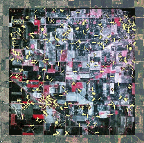
Input Image
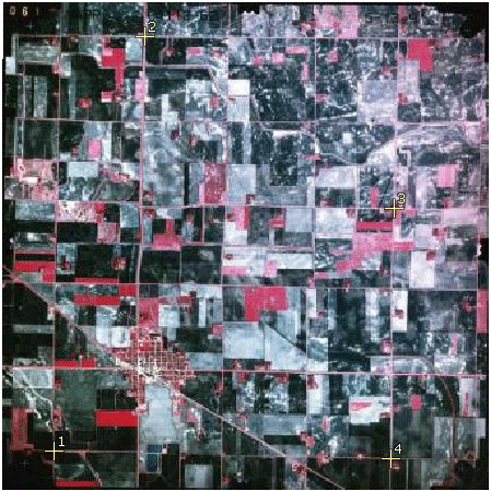
Color-infrared aerial photo of Clarkfield, Minnesota and surroundings acquired 13 May 1991 by the National Aerial Photography Program (NAPP). Scan of photo (5418 columns by 5435 lines) has a cell size of 1.7 meters. Many agricultural fields are still bare in this early-season photo and show the gray-toned soils characteristic of southwest Minnesota. The four manually-placed control points (yellow) yield RMS residuals X = 1.90 cells, Y = 3.10 cells, XY = 3.64 cells using the Affine model.
Reference Image
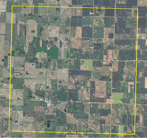
Portion of USDA NAIP 2010 natural-color orthoimage mosaic of Yellowtail County, Minnesota (MrSID file) with cell size of 1 meter. The yellow box shows the approximate area covered by the aerial photo. The images in this orthoimage mosaic appear to have been acquired somewhat later in the growing season than the input photo. Many field boundaries are also different in the two images.
Auto–Register Result
Auto-Register produced 1740 control points. Using smaller Generated Point Spacing and/or larger Maximum Point Residual values would produce more control points.
Auto-Register Settings:
Match red spectral component in each image:
Input "Green" --> Reference "Red"
Initial Accuracy Estimate: 5 cells
Generated Point Spacing: 100 cells
Maximum Point Residual: 4.0 cells
Correlation Patch Size: 128
Maximum Adaptive Model: Order 2 Polynomial
Auto-Register produced 288 control points
Using smaller Generated Point Spacing and/or
larger Maximum Point Residual values may
produce more control points.
Auto-register compared residuals using different models and found a significant improvement using the Order 2 Polynomial model, which was automatically set for the output points.
RMS Residuals:
X = 1.25 cells, Y = 1.22 cells, XY = 1.75 cells
(Model = Order 2 Polynomial)
Mean Absolute Residuals:
X = 1.05 cells, Y = 1.01 cells