Edit over Bing Maps or any web tileset or WMS layer
In the TNTgis software you can supplement your local image, map, and elevation data with the rich resource of web-based geospatial data. You can view your data from any locale over global reference image and map data from Bing Maps, or use one of the many on-line orthoimage tilesets hosted by MicroImages. Use any of these web resources as a reference as you create, edit, or georeference your local data. You can use web terrain tilesets hosted by MicroImages as terrain layers to view any of your local images (or MicroImages' on-line web tilesets) in stereo. You can also view layers published by any Web Map Service (WMS) or ArcIMS, with integrated catalog searching to allow you to select layers by text, geographic area, or address.
See also:
Tech Guides on Using Web Layers.
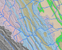
Display of web terrain tileset, WMS map layer, and local hydrology
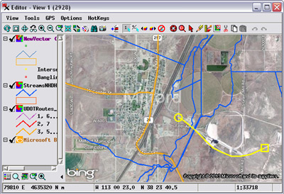
Use Bing Maps or any web layer to georeference your geodata
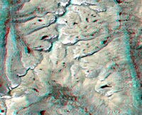
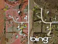
View any local image in stereo using MI web terrain tilesets
Mix Local & Web Data Highlights
- Overlay any local raster, vector, shape, CAD, TIN, or pinmap on web-based reference layers
- Bing Maps global image and map layers available as reference in every view window in TNTmips, TNTedit, and TNTview
- View reference images from MicroImages' extensive library of on-line satellite and aerial orthoimage tilesets
- View web terrain tilesets hosted by MicroImages in shaded relief, color-coded elevation, or both
- View your own custom image and web terrain tilesets that you have published on the web
- Views automatically reconcile differences in coordinate reference systems between local and web layers
- Use geospatial web layers as reference for creating and editing local data in the Editor
- Use geospatial web layers as reference for creating georeference control points for local data
- Use web image layers as reference for automatically generating hundreds of georeference control points for local images
- Overlay web-based KML files with any local or other web data
- Use all Display tools (sketching, measuring, GPS tracking) with web layers
- Use web terrain tilesets hosted by MicroImages as surface layer to view any local image in stereo
- View WMS and ArcIMS layers and adjust their transparency
- Search WMS/ArcIMS catalogs by text, by geographic extents, or by address
- Save your own list of favorite WMS/ArcIMS sites