The Editor in TNTmips lets you create or edit any type of geospatial data (raster, vector, CAD, shape, or TIN) including linked data in many file and geospatial database formats. You can use any type of geospatial data as a visual reference while editing, including Bing Maps layers and the many web tilesets hosted at MicroImages.com. The Editor includes general editing tools that are optimized for efficiency along with many specialized tools for working with particular types of data such as contours.
See also:
Tech Guides on Editing Geodata, and tutorials
Editing Vector Geodata,
Editing Raster Data, and
Advanced Vector Editing.
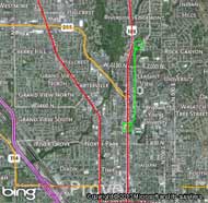
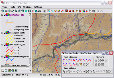
Edit over Bing Maps or any web tileset reference layer
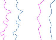
Thin and spline lines
Editing Geodata Highlights
- Create and edit raster and geometric (vector, CAD, shape, TIN) objects using any spatial data as visual reference, including Bing Maps, web tilesets, and WMS layers
- Unlimited undo/redo, automatic backups, and timed auto-save
- Save and restart editing sessions including all reference layers
- Direct editing of many external raster and geometric file types including shapefiles
- Create templates from any existing editable object for use in making new objects with same database structure, styles, and georeference
- Edit multiple layers, snap to and auto-trace elements in different layers, and convert reference layers to editable layers
- Copy, cut, and paste from one geometric or raster object to another
- Edit in stereoscopic 3D with tools following the terrain and open auxiliary 3D perspective views to assist in editing
- Context-sensitive graphic editing tools for efficient editing of geometric objects: move or extend start/end of line, or add, delete, or move any vertex without switching tools
- Smooth lines automatically while tracing
- Spline, simplify, straighten, and snap lines and apply global filters (dangling lines, bubble polygons, sliver polygons, dissolve polygons, island polygons)
- Select elements by querying attributes and step through selected set for interactive editing or filtering
- Easy assignment of attributes as you add and edit elements
- Auto-generate labels from attributes for points, lines, and polygons with control of label style, size, position, and leader lines
- Specialized tools for setting contour line values and labeling contour lines and roads
- Edit raster objects by drawing (lines, polygons, and geometric shapes), painting, flood-fill, adding text, or editing numeric values
- Insert, move, rotate, or scale CAD blocks